Exyn Nexys: Real-time 3D Mapping for Mining Surveyors
Gone are the days of snapshots and drawing for intricate architectural mapping, or scanning and vectorising mines to inform hand-drawn or computer-aided plans.
There are technologies out in the world that can do this instead, which will prove beneficial, by streamlining the process of georeferencing.
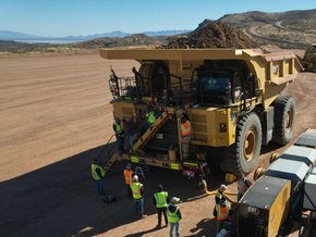
While these days they’re supported with terrestrial laser scanners and airborne varieties, mine surveyors still undergo many manual processes to form their assessments of the landscapes and environments in front of them. Luckily, the job has become easier — and safer as treacherous environments can put them in dangerous positions to carry out their work, especially underground.
Recognising the safety aspect of surveying, the dawn of unmanned aerial systems (UASs) brought with it a much safer way to carry out their work, which is again carried out manually and requires them to be trained in flying unmanned aerial vehicles (UAVs).
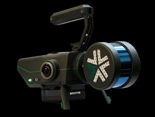
UAV-compatible solutions seem to be evolving rapidly as a result of this, which leads us to a solution that takes things one step further — the Nexys, a modular simultaneous localisation and mapping (SLAM) device enabling robots to autonomously explore and map large, complex environments without a pilot in the loop.
Exyn Technologies’ industry-leading expertise
Recognising the industry-specific challenge, Exyn Technologies is a pioneer of intelligent robotics systems, and the creator of Nexys. The company leverages the expertise from world-renowned trainers, including Boeing, Qualcomm, Magic Leap, Sikorsky Aircraft Corporation and United Technologies Research Center.
This diverse experience allows Exyn to venture down paths unknown, which quite literally inspires the technologies built for the mining sector and other GPS-denied environments.
What is Exyn Technologies’ Nexys?
Exyn recognised the need for safety in mining settings, and the growing interest for delivering highly detailed spatial mapping through a robotic platform. Moreover, the Nexys is also compact and compatible with UAVs and is fully autonomous in capturing data from all corners of its sample area.
The Nexys uses proprietary algorithms combined with next-generation SLAM and LiDAR technologies to provide autonomous, survey-grade mapping instantaneously. This means that surveyors can form their analysis in real time out in the field, streamlining their approach.
An agile companion for mine surveyors, Nexys is compatible with a number of scenarios as its configurability offers both handheld, pole and backpack orientation, and can also be mounted on aerial robots (drones), terrestrial robots and passenger vehicles. Built to IP67 standards, the unit is capable of mapping rugged, dirty environments. All things considered, Nexys is flexible and cost-effective as a one-size-fits-all solution for a variety of mapping environments.
Combine the Nexys with the ExynAero DJ34 for full autonomy and accessibility across your mining or construction site.
Real-time visualisation empowers survey teams in the field
The Nexys is paired with a ruggedized Dell Latitude tablet, synchronising the surveyor and the device to present the mapped data in real time. The user can see the environment as if looking through a camera drone with a 3-dimensional view.
This functionality is enabled by ExynView, a proprietary software that controls image data capture and post processing in unison to allow fast on-premise visibility, which can streamline surveyors’ workflows. ExynView creates clean, georeferenced point clouds through a powerful yet easy-to-use post-processing pipeline and enables data to be shared with third-party applications. The Nexys’ in-built colourisation system, comprising a group of hemispherical cameras, provides a 360-degree real-time colourised point cloud, making the solution applicable to various industrial functions across mining, construction, and critical infrastructure inspection.
3D mapping applied for mine surveying and safety
There are multiple scenarios where 3D mapping shines, but many of these environments are not only unsafe for personnel, but operators of surveillance drones and mapping solutions often find themselves battling with poor connectivity.
The team at Exyn sees this problem and delivers a solution that is operational at its best in environments where poor GPS signal may render other solutions obsolete. Exyn is well-known for delivering complex products that operate in GPS-denied environments, which can be applied across mining and construction sites. Intelligent robots built by the company are born to navigate these environments on their own and respond to challenges in unpredictable situations.
To learn more about Exyn Technologies, contact us here.
Disclosure: This article is an advertorial and monetary payment was received from Exyn. It has gone through editorial control and passed the assessment for being informative.
******
Make sure you check out the latest industry news and insights at Mining Digital and also sign up to our global conference series - Manufacturing LIVE 2024
******
Mining Digital is a BizClik brand
*************